

UAE satellite captures striking new images of Ajman and Umm Al Quwain
MBRSC shares first visuals from MBZ-SAT and Etihad-SAT satellites
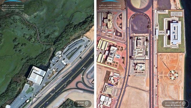
DUBAI – Two newly released images from space are giving the world a striking new perspective of the UAE’s natural and urban beauty.
Captured by MBZ-SAT, the most advanced imaging satellite in the region, the photographs reveal Ajman’s Al Zorah Nature Reserve – a sanctuary of mangroves and waterways – and the iconic UAE Flagpole in Umm Al Quwain.
Today, we are sharing two new images captured by MBZ-SAT, the most advanced satellite in the region. They showcase Al Zorah Nature Reserve in Ajman and the UAE Flagpole in Umm Al Quwain.
— MBR Space Centre (@MBRSpaceCentre) October 9, 2025
MBZ-SAT delivers imagery with twice the accuracy of previous capabilities. pic.twitter.com/EnqssQp0lY
The Mohammed Bin Rashid Space Centre (MBRSC) shared the images this week to mark World Space Week 2025, highlighting the precision and clarity now achievable through UAE’s latest space technology. The new imagery highlights MBZ-SAT’s ability to deliver visuals with twice the accuracy of previous satellites, offering unprecedented detail for both scientific and environmental analysis.
We selected Hudayriyat Island in Abu Dhabi, and Palm Jumeirah in Dubai to be the first two images we share from Etihad-SAT.
— Salem AlMarri سالم حميد المري (@Salem_HAlMarri) October 7, 2025
Etihad-SAT is a key mission in advancing and diversifying Earth observation technologies at MBRSC. As a Synthetic Aperture Radar (SAR) satellite, it… pic.twitter.com/6D2lPstdMS
These captivating views from orbit also serve as a celebration of how far the UAE’s space journey has advanced in just a few short years – from building satellites to capturing the nation’s essence from hundreds of kilometres above Earth.
MBZ-SAT and Etihad-SAT
MBZ-SAT, named in honour of His Highness Sheikh Mohamed bin Zayed Al Nahyan, President of the UAE, was launched in January 2025 and uses optical imaging to achieve exceptional accuracy. Etihad-SAT, launched two months later, is the Centre’s first Synthetic Aperture Radar (SAR) satellite, capable of capturing detailed images in all weather and lighting conditions – day or night.
The Mohammed Bin Rashid Space Centre has released the first set of images captured by MBZ-SAT and Etihad-SAT, coinciding with World Space Week 2025. pic.twitter.com/QgKCFL36dM
— Dubai Media Office (@DXBMediaOffice) October 7, 2025
Together, they form a complementary pair: MBZ-SAT offering colour-rich optical clarity and Etihad-SAT providing radar precision that cuts through clouds, fog, and darkness.
Sharper, smarter, faster
Built and designed by Emirati engineers, MBZ-SAT weighs 750 kilograms and measures three by five metres. It is equipped with a high-resolution imaging system and onboard data processing that allows captured images to be delivered within two hours – a tenfold improvement over earlier satellites.
This is why we explore space.#WorldSpaceWeek pic.twitter.com/dTxqlzyNnH
— Salem AlMarri سالم حميد المري (@Salem_HAlMarri) October 6, 2025
Nearly 90% of its mechanical structures were made in the UAE, through partnerships with national firms such as Strata, EPI, Rockford Xellerix, Halcon, Falcon, and Emirates Global Aluminium (EGA). The satellite’s electric propulsion and star-tracking systems give it metre-level navigation accuracy, while its transmission speed is four times faster than the previous generation.
These advances make MBZ-SAT a vital tool for urban planning, disaster relief, and tracking environmental changes across the region.
Radar reach
While MBZ-SAT captures vivid optical images, Etihad-SAT brings radar precision to the UAE’s orbiting fleet. The first SAR satellite developed by MBRSC, Etihad-SAT operates in three imaging modes – spot, scan, and strip – to observe both small details and large regions.
These two images, captured by MBZ-SAT, showcase Khorfakkan in Sharjah and Al Aqah in Fujairah. They feature the precise detail provided by the camera of MBZ-SAT, the most advanced satellite in the region. pic.twitter.com/tTzapuWLJX
— MBR Space Centre (@MBRSpaceCentre) October 8, 2025
Its radar capability allows it to see through clouds and operate under any lighting conditions, making it indispensable for monitoring maritime routes, oil spills, agricultural lands, and natural disasters. Advanced artificial intelligence processes its data, improving speed and accuracy for government, research, and private sector users.
Developed in collaboration with South Korea’s Satrec Initiative, the project ensured hands-on training for Emirati engineers, transferring valuable expertise to support the UAE’s long-term goal of independent satellite development.