

UAE weather alert: Wind, clouds and rain chances return this week
Oman prepares for thunderstorms and flood risks from Tuesday

DUBAI – The United Arab Emirates (UAE) is entering a period of shifting spring weather marked by fluctuating temperatures, increasing cloud cover and renewed chances of rainfall.
Following one of the wettest spells in recent months, conditions have stabilised briefly, but forecasters indicate another, weaker weather system is set to influence the country in the coming days.
This transition aligns with the seasonal “Sarayat” period, known across the Gulf for sudden atmospheric changes, convective cloud formation and occasional thunderstorms.
UAE weather today
Fair to partly cloudy skies are expected across the UAE on Monday, gradually becoming cloudier by night, particularly over western regions and offshore islands, according to the National Centre of Meteorology (NCM). Temperatures are forecast to rise slightly, reaching between 23°C and 28°C in coastal areas, up to 30°C inland, and ranging from 9°C to 18°C in mountainous regions.
Winds will be light to moderate, blowing north-westerly to south-westerly at speeds of 10 to 25 km/h, with gusts reaching up to 40 km/h at times. These conditions may lead to blowing dust and reduced visibility in exposed areas.
#Sea #Sea_Alert #Arabian_Gulf #NCM#تنبيه #حالة_البحر #الخليج_العربي #المركز_الوطني_للأرصاد pic.twitter.com/J9HyNBXcDU
— المركز الوطني للأرصاد (@ncmuae) March 30, 2026
Sea conditions are expected to be moderate to rough in the Arabian Gulf, while the Sea of Oman will see slight to moderate waves, turning rough at times. In Abu Dhabi, similar conditions are forecast, with cloud cover increasing into the evening and winds occasionally strengthening.
Midweek changes
From Tuesday through Wednesday, weather conditions are set to turn partly cloudy to cloudy, with chances of light to moderate rainfall across scattered areas of the country. The NCM has indicated that most rainfall will remain mild, although isolated heavier showers cannot be ruled out in limited locations.
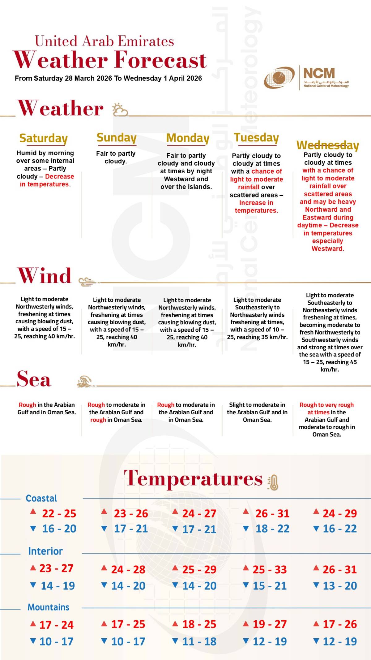
The expected rainfall is linked to a weaker weather system compared to the intense episode recorded between March 21 and 28, which ranked among the heaviest rainfall events in the UAE in around 80 years of documented records. Forecasters stress that the upcoming system carries lower moisture levels and reduced intensity.
Rainfall is most likely to affect southern inland regions, areas around Al Ain, and some internal parts of the country. Alongside the rain, temperatures are expected to drop slightly, particularly in western regions, bringing cooler conditions through midweek.
Winds may freshen during this period, reaching speeds of 40 to 45 km/h, potentially causing dust and reduced visibility. Sea conditions could also deteriorate, becoming rough to very rough at times, especially in the Arabian Gulf.
End-week shift
By Thursday and Friday, conditions are expected to improve gradually, with a return to fair to partly cloudy skies across most areas. However, humidity levels are likely to rise during the night and early morning hours, increasing the chances of fog or mist formation in coastal and internal regions.
Cooler weather is expected to persist into the latter part of the week, even as rainfall chances diminish. The NCM has not forecast additional rain beyond April 2, indicating a more stable pattern moving into the weekend.
Oman weather
Meanwhile, neighbouring Oman is preparing for a more intense spell of unstable weather conditions. Authorities have warned of thunderstorms, strong winds and potential flash flooding between March 31 and April 2 as a low-pressure trough moves across the Sultanate.
التوقعات جاءت مبشرة وثابتة بمتداد أخدود من منخفض جوي ويتميز هذا الأخدود بفرص لتشكل سحب ركامية رعدية مصحوبة بأمطار متفرقة، وقد يتحرك ليؤثر على مناطق أوسع من الامارات وشمال عُمان ابتداء من يوم غد وحتى صباح يوم الاربعاء الحالة سريعة والله اعلم#مركز_العاصفة pic.twitter.com/YGoK9nR2wK
— مركز العاصفة (@Storm_centre) March 30, 2026
Cloud activity is expected to begin over Musandam, Al Buraimi, Al Dhahirah, North Al Batinah, Al Wusta and Dhofar from Tuesday, bringing light to moderate rainfall initially. Conditions are forecast to intensify from Wednesday into Thursday morning, extending to Muscat, Al Dakhiliyah, North and South Al Sharqiyah and South Al Batinah.
Rainfall may become thundery at times, accompanied by active winds ranging between 27 km/h and 55 km/h. Authorities have warned of possible flash floods in wadis and low-lying areas, along with reduced visibility during heavy rain.
Sea conditions along Oman’s coastlines are expected to deteriorate, with waves reaching between two and three metres. Residents have been advised to avoid marine activities during thunderstorms and remain alert to rapidly changing weather conditions.